Kanchenjunga Trek - 23 Days

Trip Facts

Duration:
23 days
Trekking Region:
Destinations
Max. altitude:
5143m
Grading:
Moderate to Demanding
Best Time:
March-May/ October- November
Group size:
min 2- max 12
Accomodation:
Tea house and lodge
Meals:
Lunch, Breakfast and Dinner
Trasportation:
Flight and Private vehicles and Porters

Trip Highlights

  • Explore the less traversed Eastern mountainous regions of Nepal and the meeting points of Nepal, Tibet and Sikkim
  • The abode and playground of gods, goddesses, divine personalities, sages, and the most sacred and holiest Himalayan region
  • Exploration of the high-Himalayan culture and traditions of diverse ethnic groups like Limbu, Sherpa, Rai, and Gurung
    Widely diversified flora and fauna in the Kanchenjunga Conservation Area (Asian black bear, snow leopard, red panda, golden-breasted, red-billed chough, and blood pheasant)
  • Opportunity to explore up close the magnificence of the Himalayan peaks like Mera Peak, Khabur, Makalu, Rathong, Twin Peak, Khumbhakarna Peak, and Kabru Dome
  • Kanchenjunga Base Camp (5,140 meters) and Kanchenjunga Glacier and excellent view of Janu Himal (7710m) and Kumbhakarna Himal (Beautiful and holy Himal)
  • Expedition on the region of the second-tallest mountain in Nepal and High-Himalayan passes like Tamo La Pass, Sele La Pass, Mirgin La, and Sinon La
  • Pathivara Mata temple which is recognized as the most significant Hindu temple of Goddess Pathivara and holy place of Kirants.
  • Scenic drive through the sloped tea gardens and cardamom forest in Illam and quiet and serene trails that pass through diverse landscapes

Trip Overview

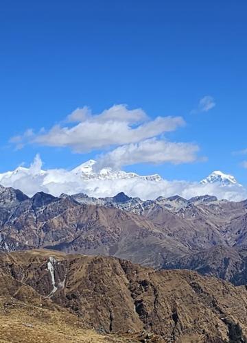
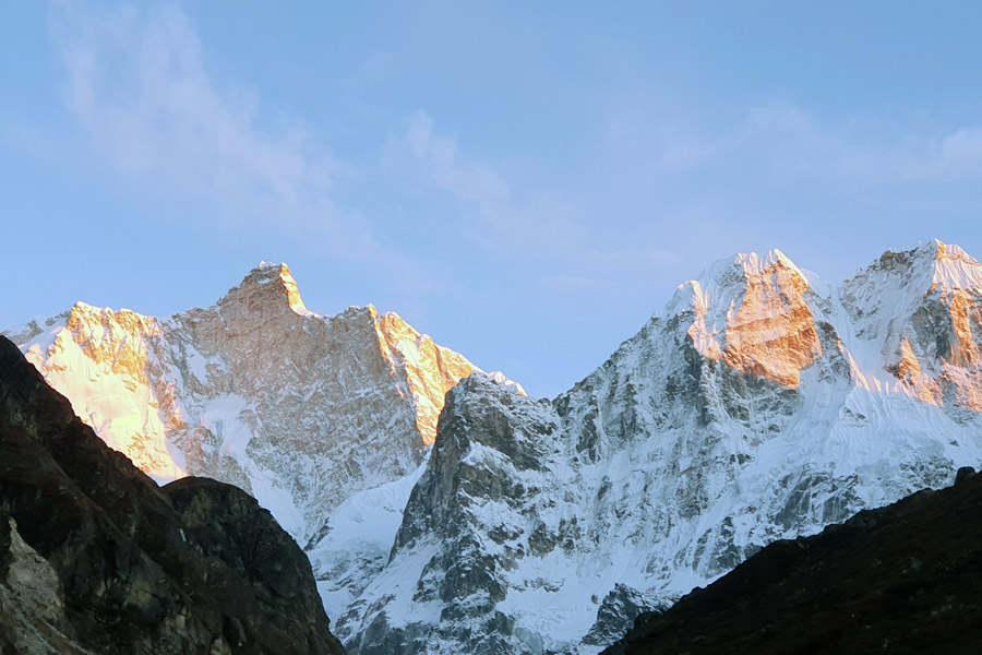
Only Everest and K2 are taller than Kanchenjunga (8586m), the massive block of rock and ice that straddles the border between Nepal and Sikkim in India. There have been relatively few attempts to climb this mighty mountain, partly because Kanchenjunga is worshipped as a tutelary spirit by the Sikimese. The first serious attempt to conquer the peak was the 1905 expedition led by the occultist Aleister Crowley, but a British team finally gained the summit in 1955. Even today, most expeditions stop just below the summit as a gesture of respect. 

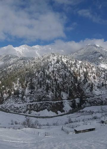
The foothills of Kanchenjunga have been open to trekkers since 1988, but permit restrictions mean that it's only possible to walk here as part of an organised trek arranged through an agency. There are two main approach routes to Kanchenjunga. The trek to the south base camp starts from the airstrip at Suketar( near Taplejung), taking two weeks to climb to the Yalung Glacier and return. The difficult 18-day trek to the north base camp can be started from Basantapur (near Hile) or, on a shorter route from Suketar, for the ultimate in Kanchenjunga experiences it is possible to combine these two treks by crossing the Mirgin La (4663m) or the Lapsang La (5160m) to make a neat three-week-plus loop. 

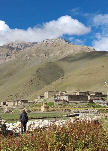
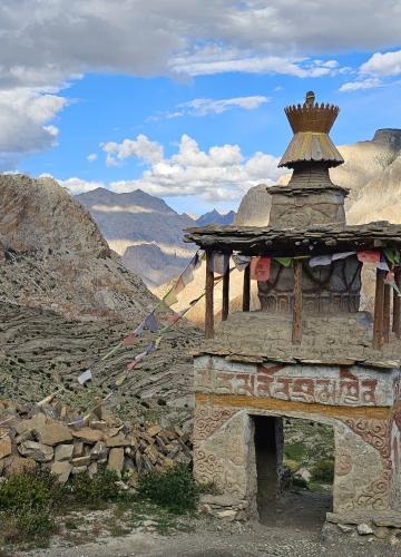
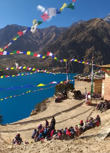
The Kanchenjunga area is the homeland of the Limbu People, who speak a language related to Tibetan and follow a mixture of Buddhist, Hindu and animist beliefs. 

Detail Itinerary

Upon your arrival in Kathmandu, you will sort out your immigration parts and our representative will be at the airport to collect your baggage and drop you off in the hotel. Depending on your arrival you can schedule your time for rest or short sightseeing. 

Overnight: In Hotel 

Elevation: 1350m 

Flight from Kathmandu to Bhadrapur, Ilam, Taplejung (2400m) take 45 minutes. 

For the Bhadrapur flight, we fly in the evening and will continue the drive to Taplejung the next day. 

We can start on the narrow trail that winds along the north bank. After a few ups and downs beside the river, you will reach some stone steps that scramble high above the river to a waterfall and the tiny hamlet of Ghaiyabari (2150m). Here, the incline becomes gentler, as you follow an exposed and precarious trail above steep grassy slopes to a crest at 2530m. Finally,  descend to the Tibetan settlement of Amjilosa (2490m), a loosely defined village with several scattered tea houses and campsites. 

Duration: Approx 5 hours 

Elevation: 2490m +890m, 

Overnight: Lodge 

This relatively short day continues to climb along the Ghunsa Valley. You will feel the mountains getting closer as you climb to a flat ridge and meander through a forest of Bamboo, Rhododendron and Gnarled brown oaks, passing scattered pastures and waterfalls. 

Eventually, you will come to a large cascade on the Ghunsa Khola. Here the trail begins a grinding climb to the Sherpa Village of Gyabla (2730m), called Chapla or Kyapra. The village has a good campsite and some teahouses with rooms. The far side of the valley is densely forested, but the slopes around Gyabla have been denuded by woodcutters. 

Duration: Approx 4 hours 

Elevation: 2730m 

Height Difference: +340m  

The day begins with a steep drop into a ravine, followed by an easy-level stage through fir and rhododendron forests along the riverbank. It takes all morning to trek to the yak pastures and potato fields of Phole (3210m). There are several teashops here and the small wooden gompa contains several ols statues and thankas(cloth painting) transported here from Tibet. 

Above Phole, the valley widens and the trail improves as you trek through fields and larch forest, dipping down to the riverbed before crossing to Gunsa (3410m). This is the largest village on the trek and Buddhist prayer flags flutter over the rooftops. Beyondsquare chorten at the start of the village are several lodges and a few shops with a fair stock of trekking suppliers. Two trails lead on from Ghunsa. The trail to Pang Pema continues north along the river, while the path to Lapsang La and Mirgin La runs south towards the small Yamatari Khola. 

Duration: Approx 7 hours 

Elevation: 3410m 

Overnight: Lodge 

Height Difference: +680m 


You have now entered serious mountain country. An acclimatisation day at Ghunsa is mandatory to reduce the risk of AMS in the later stages of the trek. 

Ghunsa is an attractive place to kick back for a day- many people use this rest day to stroll up to the fading gompa above the village, but you can also take a rewarding day hike along the trail to Lapsang La, following the Yamatari Khola to a lake at the terminal moraine of the Yamatari Glacier. 

Heading North from Ghunsa, the trails make a gradual ascent through a forest of larch and juniper along the east bank of the river. After crossing a sandy, boulder-strewn floodplain, the part crosses a rickety, wood and stone bridge to the west side of the river at Rambuk Kharka(3720m). The hillsides become increasingly barren as you climb along the valley. 

Continue north past a waterfall then make a short, steep ascent over a very unstable scree slope. Beyond the landslides, the trails climb gradually and then drop down to Khambachen (4150m), a Tibetan outpost of about a dozen shingle-roofed stone houses, wedged into a side valley at the confluence with the Nupchu Khola. There are flat areas for camping on both sides of the stream and a few teahouses including the excellent Kanchenjunga White House, which has pristine white sheets on the beds and good food. 

Overnight: Lodge

Elevation: 4150m 

Duration: Approx 6 hours 

Height difference: +740m 

Above Khambachen, the trail enters a desolate landscape gouged by the icy fingers of glaciers. The path climbs gradually across the slopes. Prepare for a serious cold. Above Ramtang, the trails run along the lateral moraine of the Kanchenjunga glacier, following the north bank of the river to a wooden bridge at the mouth of the Lhonak glacier. On the east side of the valley is the crown-shaped ridge of Mera Peak (6344m), not to be confused with the famous Mera Peak east of Lukla or Kongmatse near Lobuche. 

The village of Lhonak (4790m) sits beside a wide, often dry lakebed, on an open, sandy plain. Water is scarce here but some large boulders provide shelter for tents. The view from here is stupendous in every direction. Across the Kanchenjunga glacier, the door wedge summit of Chang Himal (Wedge peak: 6750m) dominates the valley. 

Overnight: Lodge 

Elevation: 4790m 

Duration: Approx 5 hours 

Height Difference; +640m 

The endpoint for the trek is the base camp for an ascent to the north face of Kanchenjunga at Pang Pema (5140m). It would be possible to make an arduous day trip from Lhonak, but clouds often obscure the views by mid-morning, so most people set up a high camp on the exposed, sandy plain at Pang Pema. As soon as the sun leaves the valley, the mercury crashes- be prepared for a cold, restless night. 

Overnight: Lodge 

Duration: Approx 7 hours 

Height Difference:  +360m.-793m  

Elevation: 4760m 

Descend towards Khambachen from where we climbed on day 9. After lunch, possibilities to climb to a splendid place towards the base camp of Janu Himal (Kumbhakarna) (7710m). Dominate the camp and enjoy the sunrise on the southern slope of Jannu (7710 m). This mountain, with its lines of rare aesthetics, was climbed for the first time in 1962 by a team of French mountaineers, including the famous Lionel Terray, René Desmaison and Robert Paragot. The people of the region worship these mountains. There are many pilgrims in summer. 500 pilgrims pass during the day. There is a temple with a big rock. Very beautiful view of Janu Himal with other mountains.

Overnight: Lodge 

Elevation:  4100m 

Duration: Approx 7 Hours 

Height Difference; -687m 

Retrace the approach route to Ghunsa, following the description for Day 11. 

Overnight: Lodge

Elevation: 3415m

Duration: Approx 4 hours 

Height Difference: -681m,+176m 

We will then begin to embark on the heights to reach the greenery, the softness and the cover of the rhododendrons.
Another exceptional day. We go off-trail to reach the Belvedere ridge. We pass the viewpoint which overlooks Gunsa and the trails that we took before arriving at Gunsa. We then retrace our steps to join the path leading to the Seleley pass (4180 m).

Walking time: Approx 4h
Accommodation: in the lodge
Height Difference: +878m/-43m

We rise into the morning sun above the Kanchenjunga valley to head south of the massif. We climb to the mountain pasture to attack several salt passes with the summit of Makalu 8463m emerging on the horizon. The path rises sharply to the ridge of Mirgin la et sine la pache. There are several descents and climbs to cross the 3 passes. Beautiful view of the mountain range in the southern Kanchenjunga massif.

Breakfast, lunch and dinner are included.
Walking time: 5h to 6h
Accommodation: in the lodge
Height Difference: +492m/-862m

The day is easy. We descend by a pleasant path following the course of the Simbua Khola. The forest is thinning out more and more, opening up the view of the Kabru massif. Also surprising is this small Hindu temple dedicated to snakes, on the side of the path that leads us to Tortong.


Walking time: Approx 4h 
Accommodation: in a lodge
Height Difference: +171m/-1051m

Elevation: 3000m 

Cost Includes

  • Accommodation in the mountains (dinner, breakfast and lunch)
  • 3 nights of city accommodation (Kathmandu) with breakfast.
  • All transportation, including airport pickup and drop-off.
  • Trekking permit in the national park with special permits
  • Trekking guide, assistants guide (1 assis. for 4 guests), Porters (1 porter for 2 customers)
  • First aid medical kit (Your guide will carry the medical kit but we also advise you to bring it for your use)
  • All government and local taxes.
  • Two ways of flight from Kathmandu - Bhadrapur, Bhadrapur - Kathmandu
  • Jeeps for 3 days
  • Nepalese team insurance
  • Welcome dinner & Farewell dinner

Cost Excludes

  • Nepal entry visa at immigration at Tribhuwan International
  • Airport (TIA) (approximately 50 USD) per person monthly.
  • Trekking equipment such as sleeping bags, down jackets, and poles.
  • Shower, wifi, cell phone pill charging and device
  • Unexpected costs due to health, flight cancellation, weather conditions, etc.
  • All kinds of drinks and snacks.
  • Tips for the guide and porter after the trek.
  • insurance is mandatory for 
  • International flight

FAQs

The Kanchenjunga trip is demanding due to its remote location and high altitude in Nepal. Kanchenjunga North Base Camp’s highest peak is 5200 meters… As a result, you should be emotionally and physically prepared for the challenge of the Kanchenjunga Trek. On average, you will gain 400-800 meters of altitude per day.

The Kanchenjunga trek is long (220 kilometres) and hard, demanding a high level of fitness for three weeks of continuous trekking while carrying a light rucksack.

The finest months to trek Kanchenjunga are March to May and September to Late November.

At night, the temperature can drop to -10 C / 14 F. It will be generally warm during the day. The temperature may fluctuate depending on the month. We advise against relying on weather forecasts. It is still in its early stages.

First ascenders to climb Mt. Kanchenjunga were George Band and Joe Brown.

For the trek, you’ll need two different permits. Restricted Area Permit and Conservation Area Permit for Kanchenjunga. The permission can only be obtained if there are at least two trekkers.

Review

Leave Your Review